Scary State Infographic
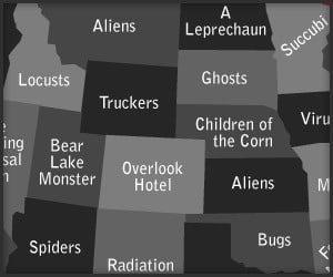
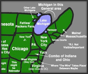
This rather amusing infographic offer some frightening speculation on what’s coming to get us depending on where we live. We truly want to know why the Succubi is coming for Minnesota.
This rather amusing infographic offer some frightening speculation on what’s coming to get us depending on where we live. We truly want to know why the Succubi is coming for Minnesota.
Artist Jennifer Collier carefully bonds, waxes, traps and stitches cardboard, thread, and road maps into contemporary textiles; that “fabric” is then fashioned into pristinely detailed everyday objects.
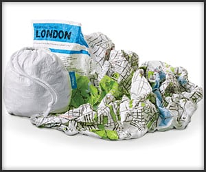
These handy city maps are made of durable and waterproof polyethylene fiber. No need to fold – they’re ready to be scrunched into a ball, stuffed in your pocket or stashed in the included pouch.
Eric Fischer made this set of maps featuring geotagged Flickr and Twitter posts. Red dots are for Flickr posts, blue dots are for Tweets and white dots are for both. Check these out too.
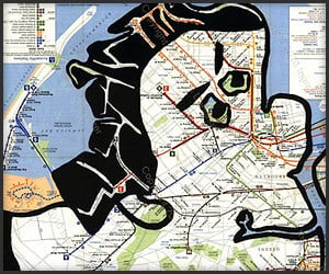
Artist Ingrid Dabringer discovers hidden forms of people in paper maps. While they’re not always the most realistic human images, each one brings unique character and charm to its locale.
Dan Abramson’s very amusing map of the USA as interpreted by New Yorkers, who apparently have no sense of geography, seems pretty fair, considering the world revolves around Gotham.
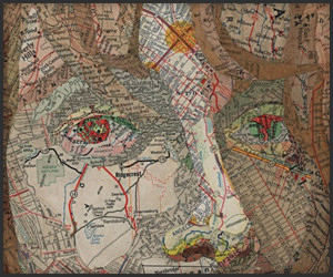
Artist Nikki Rosato makes intricate portraits by cutting maps along the street and river lines, forming a vein-like structure for her art. These 3D human forms are her most dramatic works.
Artist Matthew Cusick makes portraits and illustrations using nothing but map cutouts, using the lines, symbols and patches of colors to his advantage, to create detailed and jaw-dropping art.

While it’s not the speediest way to get around, you have to hand it to these guys who spent 5 days clicking their way across America using Google Streetview for their Demo Slam entry.
Google Earth plus Wayback Machine equals Earth Engine. The new technology stores historical and daily satellite imagery and data to allow scientists to observe planetary changes over time.
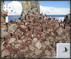
We knew that Google Street View was a cool way to explore big cities and country backroads, but we had no idea they had POV shots of Antarctica. No cars. Just snow, rocks, and lots of penguins.
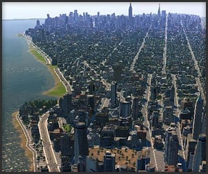
This insanely detailed digital map of New York City was created by gamer Asterion for use in the PC game CitiesXL. Try and find actual buildings you’ve been in. It’s not yet released, but we want to play.
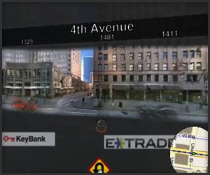
Doing their best to one-up Google Maps’ Street View, Microsoft’s prototype Street Slide uses panoramic photos to provide improved context when moving between locations on the street.
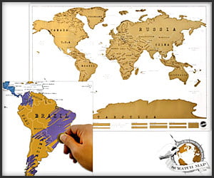
At first glance, it’s a shiny but unassuming world map. But the layer of gold foil can be scratched off to reveal a colorful and more detailed map. Perfect for globetrotters – and lottery players.
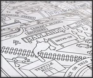
Dan Cassaro’s clever Garden State map based on Springsteen lyrics shows us where they haunt this dusty beach road in the skeleton frames of burned out Chevrolets, among other places. (Thanks Nik!)

Starting with an accurate and zoomable 8-bit map of NYC, Brett Camp now has maps of other major cities as well. The names of places in London makes its map more awesome. To Knightsbridge!
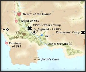
It took Jonah Adkins, a GISP (and LOSTie), about 4 years of research to finish this detailed map of the castaways’ island. Buy the poster, or find a high-res version for your desktop on Jonah’s blog.
Going on a road trip? Someone coming over to visit? Then you should check out Bing’s Destination Maps feature. Use it to make custom maps that are easy to read and fun to look at.
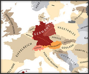
Yanko Tsvetkov pokes fun at how Europeans supposedly view each other. Apparently France thinks Italy is full of “Noisy, Friendly People,” while Germany thinks it’s just “Pizza and Museums.”
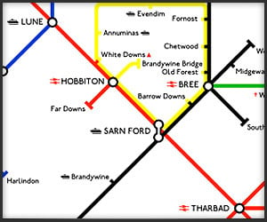
Because one does not simply catch the 11:15 to Mordor, this convenient map of Middle Earth from Reagan Lee for Threadless brings Tolkien’s world closer to ours in a modernized fashion.
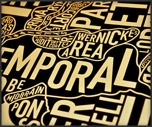
Chicago designer Jenny Beorkrem has added some anatomy to her typographically cool screenprinted city map poster collection. Check out this brain poster – do we really use all those parts in there?
Artist Christoph Niemann apes the style of Google Maps in his clever cartographic illustrations in his Abstract City column in The New York Times. We’ve been down all these roads at some point.
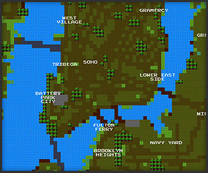
It’s loading a bit slowly at the moment, but Brett Camper’s 8-Bit NYC turns New York into a 1980s RPG-style map (think Zelda); it’s created using OpenStreetMap with 256×256 tiles.
Home | About | Suggest | Contact | Team | Links | Privacy | Disclosure
Advertise | Facebook | Twitter | Pinterest | Sites We Like
Awesome Stuff: The Awesomer | Cool Cars: 95Octane
Site Design & Content © 2008-2024 Awesomer Media / The Awesomer™